Brantford to Port Dover
Brantford is a hub for several rail trail networks going from/to Hamilton, Brantford, Paris, Cambridge, Kitchener, Delhi, Waterford, Simcoe, and Port Dover to name a few destinations.
The Brantford to Port Dover stretch mentioned on this page is a network of several trails, several of which used to be rail roads:
- Toronto Hamilton & Buffalo (TH&B) Rail Trail
- Lake Erie & Northern Rail Trail (During its days as a railroad, the LE&N railway was also affectionately called "Late, Early, or Never").
- Pleasant Ridge Trail (Not in Brantford maps; shows in Google Maps as "CN Rail Trail")
Norfolk County Rail Trails: (Simple map)
- Waterford Heritage Trail
- Norfolk Sunrise Trail
- Delhi Rail Trail
- Lynn Valley Trail
Here are several maps to get you inspired, and perhaps a bit overwhelmed:
Brant's Crossing: The Hub of Ontario Trails
City of Brantford Trail map
Norfolk County Trails interactive map
Not to worry, below you will find short sections (less than 30km to and back, and with bathrooms) for you and your family to try out over several visits and day trips.
NOTE: This trail network is not maintained from November 1 to May 1.
Section 1: Mount Pleasant to Brantford loop
Section Last ridden: June 2022
**UNCLE ERIK FAVORITE** (especially Pleasant Ridge Trail in the Fall)
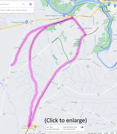
- Terrain: LE&N Trail is flat, fine stone dust Rail Trail (suitable for any bike except road bikes)
TH&B Rail Trail is all pavement North of Mount Pleasant parking lot (suitable for any bike); a little incline/decline (depending on which direction), but not by much.
Pleasant Ridge Trail is fine stone dust Rail Trail (suitable for any bike except road bikes); a little incline/decline (depending on which direction), but not by much. - Parking: Mount Pleasant Park, 555 Burtch Road, Mount Pleasant, Brant, Ontario (~10 cars)
- Food near the trail: The Windmill Country Market, 701 Mt Pleasant Rd, Mount Pleasant, ON N0E 1K0
- Washrooms: Accessible (bigger to accommodate wheelchairs) public portalet (present starting Summer 2021) at Mount Pleasant Park, 555 Burtch Road, Mount Pleasant, Brant, Ontario.
There are also bathrooms at the Windmill Country Market. - Animal Sightings: Deer spotted on Pleasant Ridge trail.
Mount Pleasant is a very common name. This is Mount Pleasant in Brant County, NOT Mount Pleasant in Peel Region or others in Ontario.
Suggested day trip:
- Park your car at Mount Pleasant Park.
- The trails (paved and unpaved) are a few metres West of the park. The first North/South trail you will encounter (the unpaved one) is Lake Erie & Northern (LE&N). Go right (North) on it. Just a few meters you'll see absolutely no trace of the where the Mount Pleasant Train Station used to be. Keep going all the way until you get to Brantford at Rotary Park, where you'll see a map kiosk near the Veteran's Memorial Parkway and a fork in the paved road. Consult the map kiosk to get an idea where you are now; the next part will need some direction.
- Here is where it can get a little confusing, so here is a map on how to make your way to the TH&B Paved trail for your return trip. From this map, you can see that at the Rotary park, take a left towards the intersection crossing Blackburn Drive and then cross the intersection crossing Veteran's Memorial Parkway. You'll be crossing into a dedicated paved path (with a little elevation). Take it all the way until you are back on the sidewalk and make your way towards the plaza where there is a grocery store and a Shoppers Drug Mart.
- Across the road you'll now see the Maple Leaf poultry plant entrance. You'll have to cross a road intersection again to make it to the RIGHT of the Maple Leaf plant entrance. DO NOT take the paved trail to the left of the Maple Leaf plant entrance. Once you are on the right of the Maple Leaf Plant entrance, stay on the sidewalk for a few more meters until you see the trailhead for the TH&B trail around the bend (it's a bit hidden).
- Now that you are on the TH&B trail, "bee" on the lookout for a sweet piece of graffiti if it's still there.
- You will come to a fork on the road. Stay straight/right, because you'll now take the Pleasant Ridge Trail, which has a little elevation, but it's off the beaten path and enjoy the nice scenery (especially in the Fall) before this area gets all developed/urbanized someday. Since it's not as busy, it can feel a little more romantic if you go as a couple.
- Once you reach the end of the Pleasant Ridge trail (it ends at Pleasant Ridge Road), turn around and make your way back down the Pleasant Ridge Trail (even more enjoyable on the way down) to the fork you encountered earlier to take the TH&B (paved) Trail back up (slight elevation) through farmland and educational plaques all the way to Mount Pleasant.
- At Mount Pleasant, you'll reach a kiosk showing you the trails and you can see which trails you did on that map. Return to the parking lot a few metres East.
- If your bikes are safely locked on your car, go visit the Windmill Country Market just down the street. This store/deli/bakery (and normally a restaurant) carries a lot of Dutch grocery items.
Section 2: Mount Pleasant to Scotland/Oakland
Section Last ridden: Fall 2023
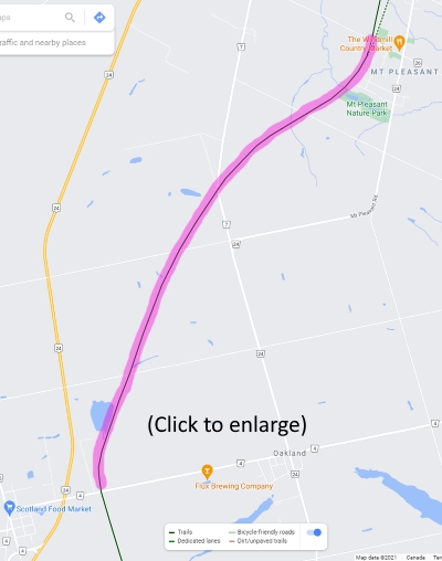
- Terrain: ALL PAVED and flat with the exception of a few unpaved meters of trail leading to the Mount Pleasant Nature Park (if you make the quick detour to see the ponds as part of your day trip)
- Parking: Mount Pleasant Park, 555 Burtch Road, Mount Pleasant, Brant, Ontario (~10 cars)
- Food near the trail: The Windmill Country Market, 701 Mt Pleasant Rd, Mount Pleasant, ON N0E 1K0
- Washrooms: Several options here. Accessible (bigger to accommodate wheelchairs) public portalet (present starting Summer 2021) at Mount Pleasant Park, 555 Burtch Road, Mount Pleasant, Brant, Ontario.
There are also bathrooms at the Windmill Country Market.
There is also a public portalet (present starting Summer 2021) at the Scotland/Oakland trailhead parking lot/kiosk. - Nearby Attractions: Mount Pleasant Nature Park. (more info)
Suggested day trip:
- Park your car at Mount Pleasant Park.
- The trails (paved and unpaved) are a few metres West of the park. The second North/South trail you will encounter (the paved one) is Toronto Hamilton & Buffalo (TH&B) Rail Trail. Go left (South) on the paved trail.
NOTE (and a nice little detour): The unpaved LE&N trail is very short going South of Mount Pleasant and leads you to a stairwell leading you to the ponds of the Mount Pleasant Nature Park (the park is primarily used for walking trails and fishing). - 500-600 metres South of the Mount Pleasant trail entrance you went through, you will see a kiosk with a map of the Mount Pleasant Nature Park. The park is primarily used for walking trails and fishing, but you can go down the little paved hill and go right (south) on the unpaved trail until you reach the stairwell leading you to the ponds, and go on top of a small dam so that you can sneak a quick peek at the ponds. There should be another map kiosk there. Once you are done looking at the ponds, make your way back where you came from to the paved TH&B trail.
- Now that you are back on the paved TH&B trail, take it South all the way, past the trailer park next to a lake, until you reach a parking lot (next to a store cleverly named "High-Way Grass Station") with a map kiosk, bench, wildlife-proof garbage can and a public portalet (present starting Summer 2021).
- Turn around to make your way back to Mount Pleasant.
- At Mount Pleasant, you'll reach a kiosk showing you the trails and you can see which trails you did on that map. Return to the parking lot a few metres East.
- If your bikes are safely locked on your car, go visit the Windmill Country Market just down the street. This store/deli/bakery (and normally a restaurant) carries a lot of Dutch grocery items.
Section 3: Scotland/Oakland to Waterford
Section Last ridden: July 2022
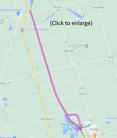
- Terrain: Paved (and flat) for only 1km (south of Jenkins Road, right next to Circus In The Trees), then it's flat, fine stone dust Rail Trail (suitable for any bike except road bikes) until you enter Waterford, and then it's paved again.
- Parking: Scotland/Oakland trailhead parking lot/kiosk, 224 Oakland Road, Scotland, ON N0E 1R0
- Food near the trail: Downtown Waterford has the Wishbone Brewing Company, Kerry's St James Street Eatery (family breakfast and short order food joint) and there is also Giorgio's Pizza (Pizza/Sub/Quesadillas take-out)
- Washrooms: There is a public portalet (present starting Summer 2021) at the Scotland/Oakland trailhead parking lot/kiosk.
- Nearby Attraction: The old Waterford rail bridge.
- Animal Sightings: In the fall, there can be baby turtles crosing the trail just south of Jenkins Road (where it turns over to the County of Norfolk and where the paved part of the trail ends). One garter snake crossing the trail also sighted in the paved part just north of it.
- Bike repair station: There is one (with air pump) near the Shadow Lake Trailhead, 77 Alice St, Waterford, ON N0E 1Y0
Suggested day trip:
- Park your car at the Scotland/Oakland trailhead parking lot/kiosk.
- Go South on the paved trail for 1km, and you'll eventually reach the Waterford Heritage Trail (part of the Norfolk County trail network (Simple map)), which is now rail trail. Keep going south.
- You'll encounter a fork in the road. Go LEFT (you'll be using the other path on your way back so you will not miss anything). This path will take you to the bridge (the other path would've taken you below the bridge).
- Once you have enjoyed the bridge, go past it and take the first stairwell to the right, close to the silos and parking lot (which is the parking lot used for the next section of trail (Waterford to Simcoe)). See this MAP for guidance.
NOTE: As per the MAP if you do not like the stairs, you can continue a little bit south and reach another fork where you can turn around and will take you on the same paved trail. - As per the MAP, go down the stairs and make a RIGHT at the (paved) Shadow Lake Trail until you are under the bridge and at the next intersection.
- At this intersection, you decide if you want to visit Waterford (there is a public washroom (portalet) at Shadow Lake Park and food options such as the Wishbone Brewing Company (and better washrooms too if you eat there)) by following the Shadow Lake Trail into town; otherwise make a LEFT (to the "Shadow Lake Trail Extension" as per the MAP) and read below for the way home.
- If you are ready to go home and made your way perpendicular to the bridge and under it and towards the Shadow Lake Extension, keep going; you'll encounter a sharp turn and then cross a smaller bridge, and then the trail will soon no longer be paved and you'll reach a road crossing (Concession 8 Townsend). Cross the road and stay on the rail trail in the same direction until you reach the Scotland/Oakland parking lot where you left your car.
Section 4: Waterford to Simcoe
Section Last ridden: July 2022
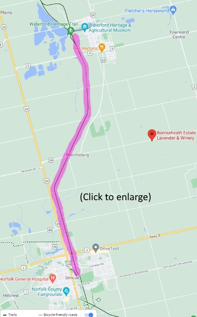
- Terrain: Mix of pavement (short bits), but mostly rail trail and doubletrack (suitable for any bike except road bikes)
- Parking (Waterford): 228 Nichol Street West, Waterford ON. Parking is at the end of Nichol Street close to the silos; you will see the trail map kiosks.
- Nearby Attraction: The old Waterford rail bridge.
- Food near the trail (Waterford): Downtown Waterford has the Wishbone Brewing Company, Kerry's St James Street Eatery (family breakfast and short order food joint) and there is also Giorgio's Pizza (Pizza/Sub/Quesadillas take-out)
- Food near the trail (Simcoe): Simcoe has a Wendy's and Tim Horton's near the intersection of the trail and Highway 3/Queensway, along with a unique ice cream shop close to the trail.
- Public Washrooms (Simcoe): There is a portalet in the parking lot of Wellington Park in Simcoe.
There is a hidden portalet behind a tiny church-like building in Clifton Park on the other side of the road from Wellington Park.
You can also try the bathrooms at the Simcoe Tim Horton's. - Safety considerations: There is no trail maintenance on the Norfolk County rail trails from November 15 to April 15.
- Bike repair station: There is one (with air pump) near the Shadow Lake Trailhead, 77 Alice St, Waterford, ON N0E 1Y0
Suggested day trip:
- Park your car at the Waterford parking lot near the silos. It's really close to the old Waterford rail bridge (a few meters north) but we will be going in the direction opposite of where the bridge is.
- Go south on the paved trail for 1km, and you'll eventually reach the Thompson Road overpass (where there is an overflow parking lot if the Nichol St parking lot is full). You could go East on Thompson Road for less than 1km to reach a Tim Horton's if you need a washroom or a caffeinated beverage.
- Past the Thompson Road overpass (and parking) it will now be rail trail mostly in the open, and then doubletrack mostly in the shade.
- You'll eventually reach Simcoe. Go south further to reach the Argyle Street parking for the trail network, with its map kiosk.
- From the Argyle Street parking lot, here is how to find the two public washrooms if nature calls.
- Feel free to explore Simcoe. Here is a map of the restaurants, ice cream shop, and public washrooms all north of the Argyle Street parking lot.
- When you are ready to go back to Waterford, head north on the trail.
- Once you reach Waterford in the paved part north of the Thompson Road overpass, you'll encounter a fork in the road with a washroom sign. The right side takes you back to the parking lot near the silos (and the bridge). The left side takes you downtown Waterford where you'll find a portalet at Shadow Lake park (reason for the washroom sign) and a brewery/eatery across the park and some food options (but not as many as Simcoe) on Main Street S and St James Street S.
Section 5: Delhi Rail Trail
Section Last ridden: September 2021
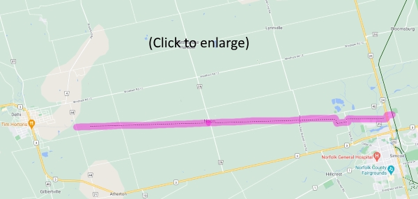
- Terrain: Mix of Public streets (less than 1 km), singletrack (2 km - poor drainage; this part of trail is best after 2-3 sunny days in a row) until and around the Toyotetsu plant, and then it's mostly Rail Trail (suitable for any bike except road bikes; good drainage)
- Parking (Simcoe): Lion's Park, 55 Davis St East, Simcoe, ON N3Y 4K3
- Public Washrooms (Simcoe): There is a portalet in the parking lot of Wellington Park in Simcoe.
There is a hidden portalet behind a tiny church-like building in Clifton Park on the other side of the road from Wellington Park.
You can also try the bathrooms at the Simcoe Tim Horton's. - Other amenities (Simcoe): One of those little free libraries (take a book, leave a book) on Davis Street West near North Court (on the way to the start of the Delhi trail)
Park at the Lion's Park. The Norfolk Sunrise trail is right next to it, along with signs telling you the direction to find the Delhi Rail Trail so keep going west on David Street East as directed. Cross the intersection of Norfolk Street North into Davis Street West. On Davis Street West you should see the next sign (or what is left of it as of 2021) telling you to turn into North Court. At the end of North Court, you should see the entrance to the trail along with another one of those signs.
The next 1.5km will have you go through singletrack until the Toyotetsu plant. The trail continues left of the plant (there will be a map kiosk once you get left of the plant on Park Road). You then go around the plant for a bit and once you rejoin the trail everything will be straight from then on and will be rail trail.
Enjoy the pumpkin fields (if you ride there in September) and other fields before you transition into forest. There will also be some educational plaques telling you about the conservation of Carolinian forest and tall grass prairies (Tall grass prairie is a natural ecosystem that was once found throughout southwestern Ontario. Today only one per cent of Ontario’s original tall grass prairie remains, making it the province’s most threatened ecosystem... but there are some restoration efforts out there).
With its trees, it also feels like the kind of trail that you could really go fast on a cyclocross/gravel bike and it will give you a sense of speed as the nearby trees are whizzing past you and also blocking any wind that would otherwise hit you if you were out in the open.
Despite its name, the trail does not reach Delhi.. only its outskirts at Fertilizer Road. From there, it is possible to go on 2-3 km of public roads to reach Delhi and explore if you want (it's got a KFC, Tim's, and some Pizza places), it's up to you. Once you're done, take the Delhi Rail Trail back to Simcoe where you parked.
Section 6: Port Dover to Simcoe
Section Last ridden: Summer 2023
**UNCLE ERIK FAVORITE**
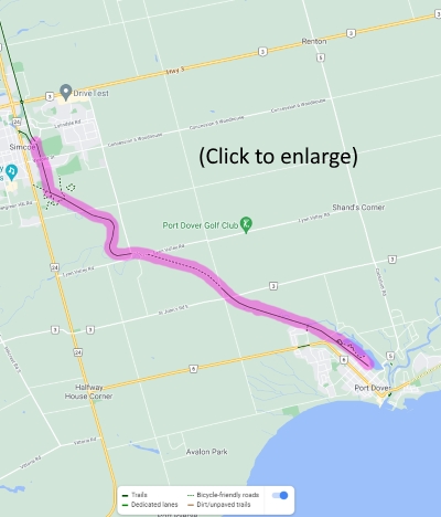
- Terrain: Flat, fine stone chip Rail Trail (suitable for any bike except road bikes). Only one small section on public road once you reach Lynn Valley Road; follow the directions HERE to find your way back to the trail.
- Recommended Parking: Silver Lake Park, 330 Bridge Alley, Port Dover, ON N0A 1N6
- Food near the trail (Simcoe): Simcoe has a Wendy's and Tim Horton's near the intersection of the trail and Highway 3/Queensway, along with a unique ice cream shop close to the trail.
- Public Washrooms (Port Dover): There is (normally) a portalet right next to Silver Lake Park at the corner of the Port Dover Lions Silver Lake Market parking lot.
- Public Washrooms (Simcoe): There is a portalet in the parking lot of Wellington Park in Simcoe.
There is a hidden portalet behind a tiny church-like building in Clifton Park on the other side of the road from Wellington Park.
You can also try the bathrooms at the Simcoe Tim Horton's. - Safety Considerations: Deer Tick warnings in this (Lake Erie) part of Ontario but as long as you stick to the paved/rail trail, you should be fine. Bring DEET (and/or cover your legs) just in case, especially if you are going to go off-road by Brook Conservation Area in Simcoe.
- Animal Sightings: If you are lucky, you may see the occasional garter snake crossing the trail.
- Other amenities: One of those little free libraries (take a book, leave a book) at the Silver Lake Park parking lot.
Suggested day trip:
- Park your car at Silver Lake Park.
- Go North on the trail. It will eventually be nicely shaded with good tree coverage. You'll cross a few bridges.
- Once you reach Lynn Valley Road, follow the directions HERE to find your way up Lynn Valley Road back to the trail.
- More shaded trail. Once you reach Simcoe, you'll reach a fork in the road and some off-road stuff (bring DEET and/or cover your legs if you are going to do the off-road stuff).
- Going straight at the fork will get you to Simcoe Memorial Park (a ballpark, where I believe you may (or may not; I forget) find a portalet or other public washroom).
- Going right at the fork is the actual way to go to continue in the trail network all the way to Simcoe/Waterford/Brantford and beyond, so go right (north; Google shows it as LE&N Trail). You'll eventually reach the Argyle Street parking for the trail network, with its map kiosk.
- From the Argyle Street parking lot, here is how to find the two public washrooms if nature calls.
- Feel free to explore Simcoe. Here is a map of the restaurants, ice cream shop, and public washrooms all north of the Argyle Street parking lot.
- When you are ready to go back to Port Dover, head south from the Argyle Street parking lot.
- In Port Dover, before you get back in your car, explore south a few streets and see Lake Erie since you are so close to it. It might be busy with tourists, but you are one too, so enjoy!