Elora Cataract Trailway
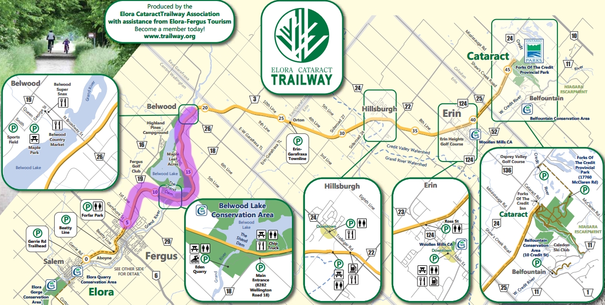
The Elora Cataract Trailway is a 47-kilometre rail trail (stone dust, relatively flat; used to be a railway) Starting at Elora, Ontario (somewhat close to the Elora Gorge Conservation Area) and ending at the Forks of the Credit provincial park.
For more information, please visit the following:
Website
Parking Lot locations
Maps
Here are the different sections for you and your family to try out, so doing this trail may require more than one visit to complete if you go with your family:
Section 1: Elora to Fergus via Trestle Bridge Loop
Section Last ridden: Spring 2025

- Terrain: Flat, fine stone dust Rail Trail (suitable for any bike except road bikes), and a few city streets in the Elora part
- Parking (East): 389 Beatty Line N, Fergus ON (recommended)
- Parking (West): 6479 Gerrie Road, Elora, ON (small lot)
- Washrooms: Fergus: Drive or cycle to Forfar Park, 605 Gartshore Street, Fergus, ON (recommend you do a bathroom stop at Forfar before you park at Beatty or Gerrie and take your bikes off the car)
Elora: Public Washrooms at Elora Splash Pad, 36 Water Street, Elora, ON (part of this bike loop, so a nice mid-ride bathroom break) - Picnic tables: Terry Fox Park, 710 Fergus Street, Fergus, ON (close to Beatty parking lot)
- Connections: The Cottontail Road Trail connects this loop to the Kissing Bridge Trailway.
Day trip idea (this loop will be a combination of Elora Cataract Trailway and Trestle Bridge Trail):
- Time your trip to arrive near Fergus shortly before 11am.
- If you need a bathroom stop after your long drive, stop at Forfar Park, 605 Gartshore Street, Fergus, ON for their public washrooms.
- If you feel like a Maritimer and crave "The Works" Pizza, "Garlic Cheese fingers", "Donairs", there is a Pizza Delight (a pizza chain mostly located in the Maritimes) at 181 St Andrew St E, Fergus, ON (if you go, grab some take-out; there isn't any real seating there). Opens at 11am.
- If you grabbed some take-out or brought your own lunch, there are picnic tables at Terry Fox Park, 710 Fergus Street, Fergus, ON (Note: I did not see any picnic tables at Forfar Park).
- Once refreshed, you can park at either the Beatty or Gerrie parking lots.
- Ride the loop clockwise. Rely on this loop map for the streets to turn into when you get to Elora. There will be limited signage on the trails and on the streets.
- You will then go turn into Waterloo Street, York St E, High St, and Water Street.
- Your mid-ride next bathroom break will be on Water Street at O'Brien Park (listed as "Elora Splash Pad" in Google Maps).
- This is where you can decide to explore Historic Downtown Elora for a bit and then come back to Water Street when done.
- From Water Street, you will be taken across a footbridge to Bissell Park.
- From Bissell park, continue north on Mary St until Church Street. Follow Church Street eastward until you reach the trail.
- Proceed on the trail to your parking lot.
- If you have extra time, you can do the Museum Trail (hilly!) and the Aboyne Forest (rough, rooty trails, more suited for mountain bikes).
Section 2: Fergus to Belwood (the town; not the Conservation Area)
Section Last ridden: Summer 2021
**UNCLE ERIK FAVORITE**
- Terrain: Flat, fine stone chip Rail Trail (suitable for any bike except road bikes)
- Parking: Forfar Park, 605 Gartshore Street, Fergus, ON
- Washrooms: Forfar Park, 605 Gartshore Street, Fergus, ON
- Nearby Attraction: You will ride your bike on the top of The Shand Dam
- Other Amenities:There is a little free library on the trail less than 100 meters East from the snowmobile map kiosk at Belwood.
Start at Forfar Park in Fergus and go East on the trail. You'll go through The Shand Dam (part of Belwood Lake Conservation Area) and continue until you hit the town of Belwood. You'll know you have arrived at Belwood when you see this snowmobile trail kiosk (the Elora Cataract Trailway is used for snowmobiles in the winter). There is a little free library on the trail less than 100 meters East from the snowmobile map kiosk.
Section 3: Belwood to Hillsburgh
Section Last ridden: Summer 2020
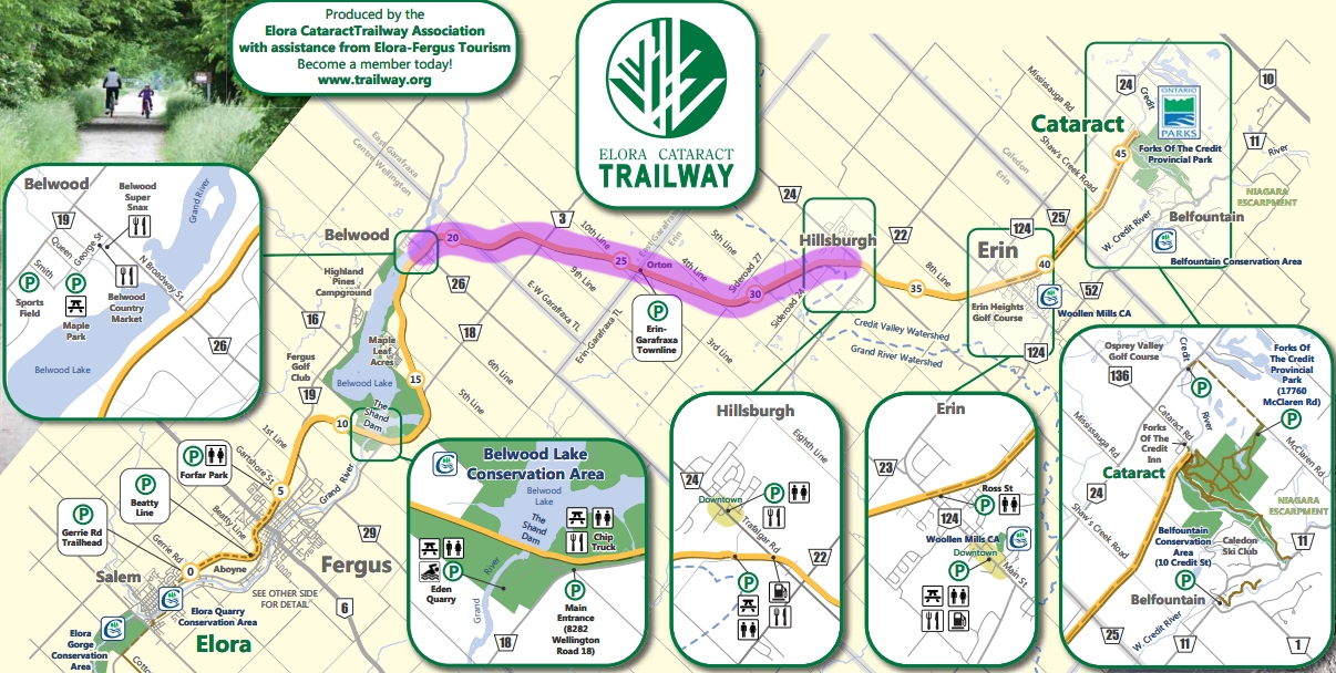
- Terrain: Mostly doubletrack with some vegetation at the center (not as good (especially after rainfall) as stone dust but still OK for any bike except road bikes)
- Recommended Parking: 11 Station Street, Hillsburgh, ON (Google Maps may show it as 8 Station Street)
Parking is right next to the trail, with a view of the pond, and normally has a washroom. - Washrooms (Hillsburgh): There is (normally) a portalet at the Hillsburgh (Station Street) parking lot.
NOTE: The portalet was not present during the 2020 pandemic. - Other Amenities:There is a little free library on the trail less than 100 meters East from the snowmobile map kiosk at Belwood.
If it rained the day before, there may still be some mud in spots for this stretch of trail. Recommendation is to start in Hillsburg and go West to the town of Belwood. You'll know you have arrived at Belwood when you see this snowmobile trail kiosk (the Elora Cataract Trailway is used for snowmobiles in the winter). There is a little free library on the trail less than 100 meters East from the snowmobile map kiosk.
Section 4: Hillsburgh to Cataract
Section Last ridden: Summer 2018
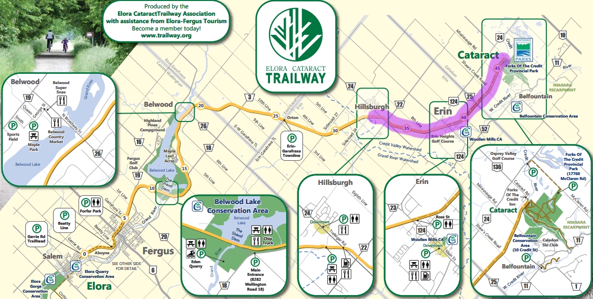
- Terrain: Flat, fine stone chip Rail Trail (suitable for any bike except road bikes)
- Recommended Parking: 11 Station Street, Hillsburgh, ON (Google Maps may show it as 8 Station Street)
Parking is right next to the trail, with a view of the pond, and normally has a washroom. - Washrooms (Hillsburgh): There is (normally) a portalet at the Hillsburgh (Station Street) parking lot.
NOTE: The portalet was not present during the 2020 pandemic.
Recommendation is to start in Hillsburg and go East, through Erin and all the way to The Forks of the Credit provincial park.