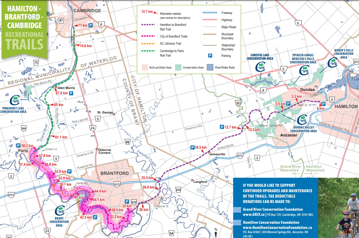
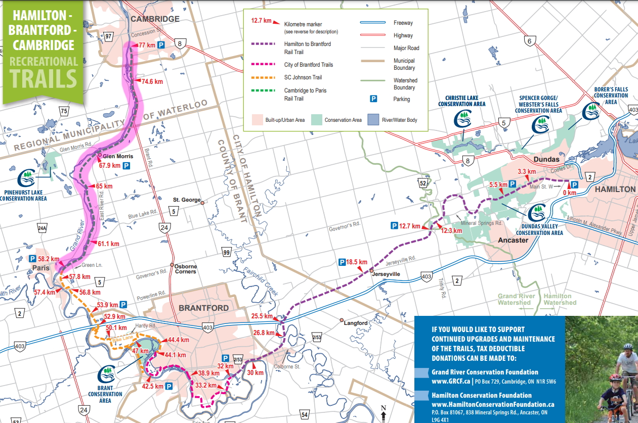
Hamilton - Brantford - Cambridge
Brantford is a hub for several rail trail networks going from/to Hamilton, Brantford, Paris, Cambridge, Kitchener, Delhi, Waterford, Simcoe, and Port Dover to name a few destinations.
The Hamilton to Cambridge stretch mentioned on this page is a network of several trails, several of which used to be rail roads:
- Hamilton to Brantford Rail Trail (includes both the Hamilton Conservation Authority Trail and the Grand River Conservation Authority Trail)
- Gordon Glaves Grand River Loop (AKA Gordon Glaves Memorial Parkway) (part of the City of Brantford Trail)
- SC Johnson Trail (part of the City of Brantford Trail)
- Paris to Cambridge Rail Trail
Here are Some Sights To See Along The Way
Note: The Hamilton to Brantford and the Brantford to Port Dover sections combine together as Brock's Route, connecting Lake Ontario to Lake Erie.
You'll see signage from time to time telling you that you are in a part of the route.
Here are several other maps to get you inspired, and perhaps a bit overwhelmed:
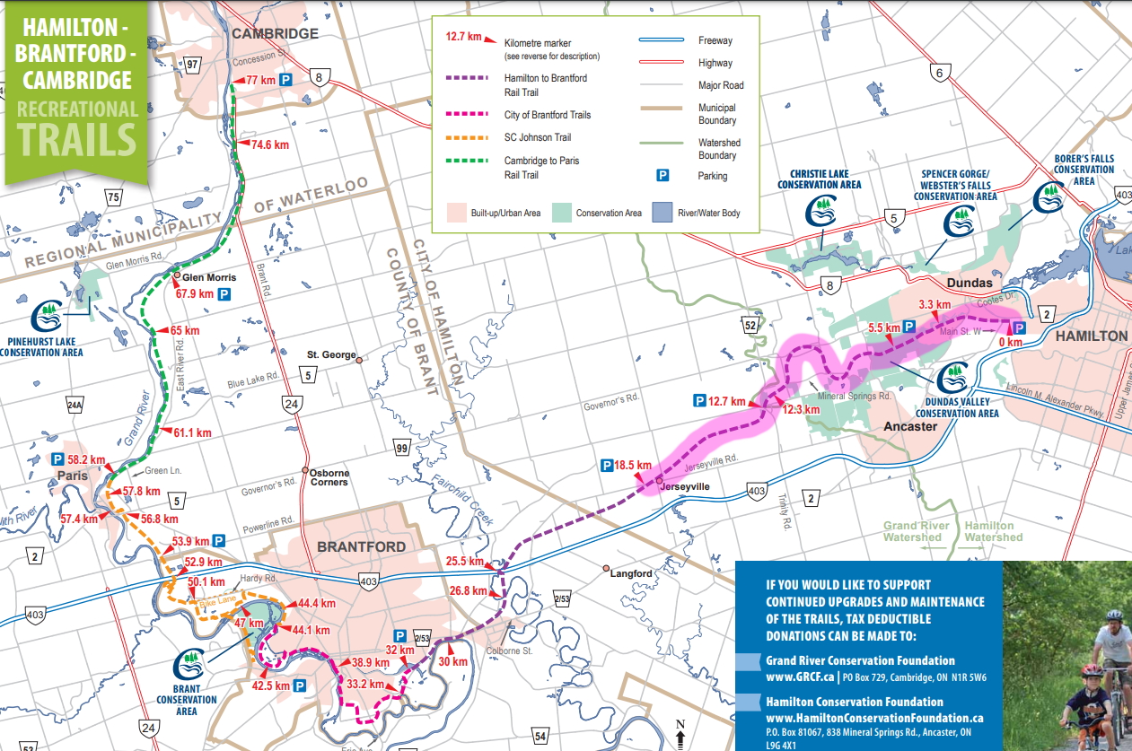
Hamilton - Brantford - Cambridge trail map
County of Brant Trails
Brant's Crossing: The Hub of Ontario Trails
City of Brantford Trail map
The sections below may seem a little longer (~40km total for each strech), but some family-friendly alternatives will also be offered for each section and to address any possible safety issues.
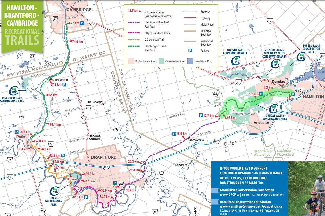
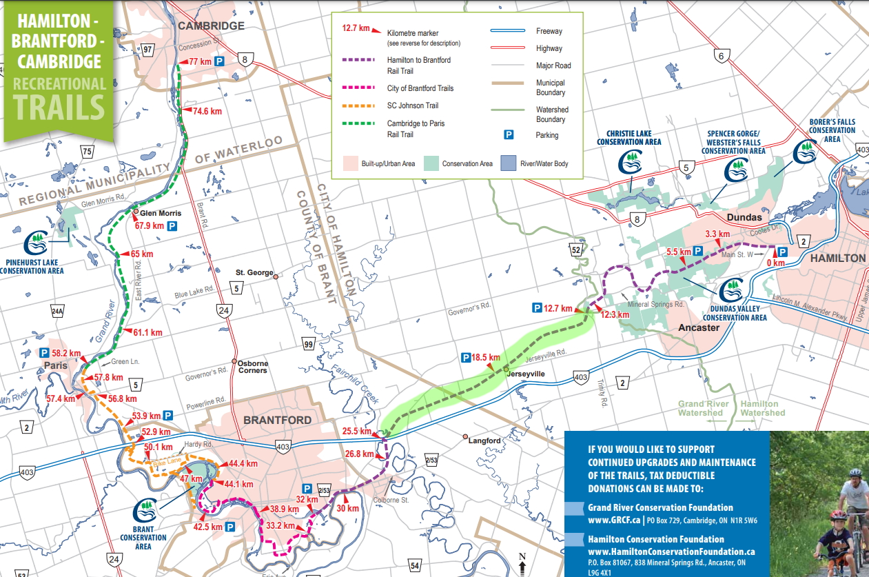
REGULAR (Grown-up) Section 1: Hamilton to Jerseyville
(some) Section Last ridden: Spring 2023
- Terrain: Flat, fine stone dust Rail Trail (suitable for any bike except road bikes)
- Parking (Hamilton): Rail Trail parking, 34 Ofield Rd, Hamilton, ON L8S 2M5 (~15-20 cars)
- Parking (Hamilton): Sanctuary Park parking Lot, ~30 Sanctuary Dr, Dundas, ON (~10-15 cars)
- Parking (Jerseyville): Hamilton to Brantford Rail Trail - Jerseyville Road West Trailhead, 2765 Jerseyville Rd W, Hamilton, ON L0R 1R0 (~15-20 cars)
- Washrooms: At the Dundas Valley Conservation Area, in the old train station. Possibly also a portalet at Sanctuary Park (but that needs to be verified)..
- Safety consideration: Highway 52 is a highway (cars go 80km/h and do not stop) and you have to cross it to continue.
- Other information: The old train station at Dundas Valley Conservation Area has picnic tables and a drinking fountain inside with a method of filling up a water bottle.
- Make it a day trip: Once done, drive over to the Ancaster Ice Cream Parlour, with anywhere from 80-120 flavours (some come and go), and other snacks (because it's near a baseball park)
Sanctuary Park parking lot is a nice area to park, but the rail trail parking is closer the to one of the ends of the trail. The trail continues East for a bit after the parking lot, but it's all urban there anyway.
You can also start your journey at the Jerseyville parking lot and go East.
The trail is a slight incline when you go Westbound (so it is a slight decline if you go Eastbound).
You'll see some nice signage at some intersections to help you get your bearings.
Regardless of which direction you decide to go, there is a slight safety concern when you'll cross Highway 52. It is busy and the cars go 80km/h and will not stop for you (it is technically a highway). The family-friendly version of this section ends the trip at this Highway so that you won't risk either your kids crossing it, and/or waiting forever for an opening. Grown-ups will be fine; it's just an annoyance.
The Rail Trail Parking lot on Olfield Road is very close to the Fairweather Brewing Company They do not offer food, but you can bring your own food (check their website for details).
FAMILY-FRIENDLY Section 1: Hamilton to Hwy 52
(some) Section Last ridden: Spring 2023
- Terrain: Flat, fine stone dust Rail Trail (suitable for any bike except road bikes)
- Parking (Hamilton): Rail Trail parking, 34 Ofield Rd, Hamilton, ON L8S 2M5 (~15-20 cars)
- Parking (Hamilton): (better parking when with young kids due to nearby playground) Sanctuary Park parking Lot, ~30 Sanctuary Dr, Dundas, ON (~10-15 cars)
- Parking (Hwy 52): (NOT free; perhaps free if you have a HCA membership) Summit Bog parking Lot, 525 Highway 52, Jerseyville, ON (~10-15 cars)
- Washrooms: At the Dundas Valley Conservation Area, in the old train station. Possibly also a portalet at Sanctuary Park (but that needs to be verified)..
- Safety consideration: Highway 52 is a highway (cars go 80km/h and do not stop); turn around there; please do not cross the highway with very young children.
- Other information: The old train station at Dundas Valley Conservation Area has picnic tables and a drinking fountain inside with a method of filling up a water bottle. Sanctuary Park has a playground with a slide, monkey bars, etc.
- Make it a day trip: Once done, drive over to the Ancaster Ice Cream Parlour, with anywhere from 80-120 flavours (some come and go), and other snacks (because it's near a baseball park)
Sanctuary Park parking lot is a nice area to park, but the rail trail parking is closer the to one of the ends of the trail. The trail continues East for a bit after the parking lot, but it's all urban there anyway.
The trail is a slight incline when you go Westbound (so it is a slight decline when you go Eastbound).
You'll see some nice signage at some intersections to help you get your bearings.
Turn around once you hit Highway 52 (there is another trailhead there and a parking lot). I would not consider this highway safe to cross with little ones. It is busy and the cars go 80km/h and will not stop for you (it is technically a highway). You'll be able to see the other side of the trail if you follow the family-friendly section 2 plan later down this page.
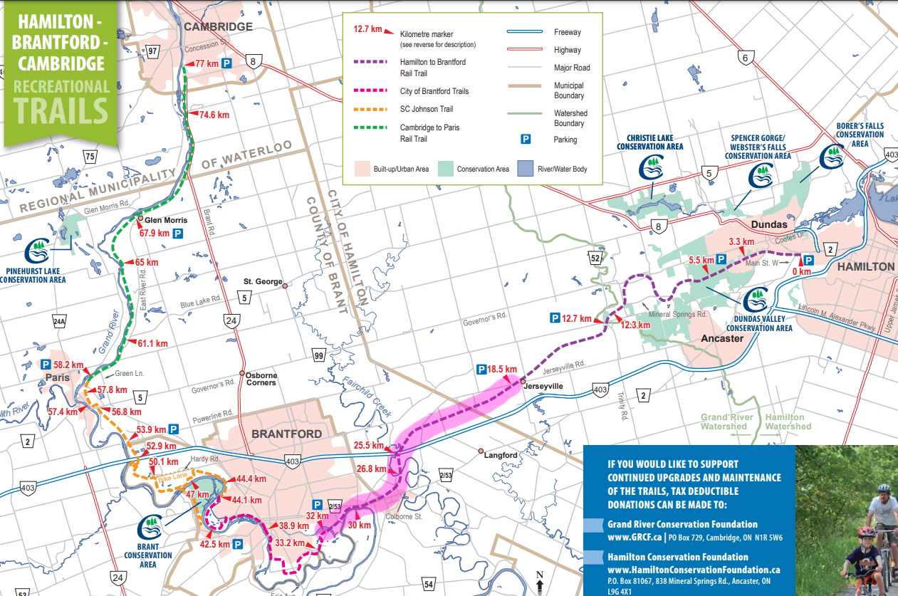
REGULAR (Grown-up) Section 2: Jerseyville to Brantford
Section Last ridden: Summer 2023
- Terrain: Flat, fine stone dust Rail Trail (suitable for any bike except road bikes)
- Parking (Jerseyville): Hamilton to Brantford Rail Trail - Jerseyville Road West Trailhead, 2765 Jerseyville Rd W, Hamilton, ON L0R 1R0 (~15-20 cars)
- Washrooms/Food: None on the trail. However there is a Tim Horton's near the Papple Road crossing in Cainsville.
- Safety consideration: At one point you are going under the 403. Don't go too fast downhill because there is a risk of collision because of tree coverage.
- Safety consideration: There is erosion of the trail in Brantford. There will be a sign telling you this.
- Make it a day trip: Once done, drive over to the Ancaster Ice Cream Parlour, with anywhere from 80-120 flavours (some come and go), and other snacks (because it's near a baseball park)
Park at the Jerseyvile parking lot. Proceed west; eventually you'll be going under the 403. Just be careful in that area and don't go full speed downhill.
You will eventually make it to Brant County, judging by the water tower, at the outskirts of Brantford in Cainsville. You'll probably be crossong Papple Road. Look at Google Maps and you'll see a Tim Horton's nearby if you need a bathroom/caffeine/food break.
Keep going on the trail and you'll see a plaque about a railway derailment (probably due to erosion). Speaking of erosion, you'll probaly see (unless they fixed it) a point where you'll be warned not to ride your bike any further due to erosion. Most people do anyway because they left a tiny part open for walkers. I recommend you walk your bike through that section.
You'll eventually reach a residential neighborhood (Beach Road). The trail continues just a bit further besides (but not on) Beach Road. Go further in the trail and find the next parking lot on Greenwich Road along the trail. Now that you know the next parking lot, you should consider turning around at this point.
On your way back, just be careful again as you go downhill under the 403. The area is not completely paved.
FAMILY-FRIENDLY Section 2: Jerseyville and surrounding area
Section Last ridden: Summer 2023
**UNCLE ERIK FAVORITE**
- Terrain: Flat, fine stone dust Rail Trail (suitable for any bike except road bikes)
- Parking (Jerseyville): Hamilton to Brantford Rail Trail - Jerseyville Road West Trailhead, 2765 Jerseyville Rd W, Hamilton, ON L0R 1R0 (~15-20 cars)
- Washrooms: None.
- Safety consideration: You should turn around before you get to the point where you get under the 403. This is because there is a risk of collision with incoming riders because of tree coverage when going downhill.
- Make it a day trip: Once done, drive over to the Ancaster Ice Cream Parlour, with anywhere from 80-120 flavours (some come and go), and other snacks (because it's near a baseball park)
Park at the Jerseyvile parking lot. Proceed East (towards the diagonal road crossing). Keep going until you reach Highway 52. Turn around and make your way back to the Jerseyville parking lot.
Once you are back at the Jerseyville parking lot, depending on the amount of energy the kids have, proceed West. You'll eventually reach a property with a big man-made lake with a sign telling you that this person's property is not a part of the trail. The next intersection you'll encounter will have a little 5-car parking lot for the trail.
This will be your other turnaround point. It is NOT RECOMMENDED you go any further West as you'll eventually reach the point where you'll be going under the 403.
REGULAR (Grown-up) Section 3: Brantford
Section Last ridden: September 2020
- Terrain: Mix of fine stone dust Rail Trail, paved dedicated trail, sidewalks and possible public roads (Hardy Road; Kraemer's Way) where you share the road with car traffic.
- Parking (South Brantford): Brantford Jaycees Trailhead & Parking Area, Greenwich Road, Brantford, ON N3S 7X4 (~20 cars)
- Parking (North Brantford): 250 Hardy Rd, Brantford, ON N3T 5L8
- Public Washrooms (and food?): (Needs to be verified) A short extension trail near Brantford Jaycees Trailhead on Greenwich Street leads (by crosing a small road bridge) to Mohawk Park where there are washrooms and a food stand during the summer.
There seems to be a portalet at the 250 Hardy Road parking lot.
There is a Starbucks in Paris near the trail.
There may or may not be a family-friendly option here. Some rail trail near the Brantford Jaycees Trailhead is not shaded. There might be traces of homelessness near parks (same could be said for the Simcoe part of the Brantford to Port Dover stretch). Police patrol the paved paths by motorcycle once in a while. Ride this as grown-ups yourselves first and you be the judge. Some parts of the SC Johnson Trail are REALLY good; some may be eroded. A suggested trip would be to start in Paris (Willow Street) and make your way south instead. Read on for more details on what is on the trail.
- The first portion west of the Brantford Jaycees Trailhead & Parking Area is a few kilometres of rail trail which is not shaded (so bring sunscreen) then you ride the wide sidewalk north on a public street (River Road), which turns into a dedicated paved bicycle path in the city (SC Johnson Trail).
- Continue North on the SC Johnson Trail (East side of the river) and stay on the paved path and you'll get to Wilkes Dam. A short stretch on Dufferin Avenue will lead you back on the SC Johnson trail.
- Keep going North until you reach Hardy Road, which is a public road. There is a parking lot there (250 Hardy Road) for the trail, and there may be a portalet there. This could be a good turn-around point if you want to keep the rest of the SC Johnson trail for another day.
- From the Hardy Road parking lot, you have two choices: You can go back south and explore a detour called the Blue Circle Trail. In 2020, part of it was blocked due to erosion. If it is fixed, this would be a much prettier (and away from car traffic) alternative than Hardy Road/Kraemer's Way to reach the rest of the SC Johnson Trail.
- I recommend you try the Blue Circle route anyway, because you can at least take it to the Oak Hill Trail (and its bridge), which is a few more kilometres to explore on the other side of the Grand River all the way to the Oak Hill Cemetery, and then head back to the Blue Circle trail.
- Looking at Google Maps, whether you reached the rest of the SC Johnson trail by Hardy Road/Kraemer's Way or by the Blue Circle Trail and Oak Park Road, you should've reached a parking lot at 15 Kraemer's Way (there always seem to be a vehicle or two parked there, so it's an unofficial parking spot) and the SC Johnson Trail resumes from there.
- Back on the SC Johnson Trail, the terrain will have some changes in elevation (it's not flat). You'll go around the P&G Distribution Centre, cross Highway 403 via an overpass, ride in woods a little further until you reach Paris... Ontario.
- Once in Paris, you'll be on Curtis Avenue. HERE is a map for continuing on Curtis Avenue to cross Dundas Street (there is a Starbucks nearby for caffeine/washroom/food break (and you can say that you have been at a coffee shop in Paris!.... Ontario.)) and eventually finding the trail again.
- You'll eventually reach the Cambridge to Paris Rail Trail - Paris Trailhead, Willow St, and the beginning of the Paris to Cambridge Rail Trail. This can be your turnaround point (to wherever you parked), as this guide will continue in section 4 below.
(Good for EVERYONE) Section 4: Paris to Cambridge
Section Last ridden: September 2022
- Terrain: Mostly doubletrack (suitable for any bike except road bikes), but this particular doubletrack is a bit bumpier than usual. Front suspension recommended, but not really needed (racers use cyclocross bikes on this trail as part of the Paris to Ancaster event).
- Parking (Paris): Cambridge to Paris Rail Trail - Paris Trailhead, Willow St, Paris, ON N3L 2M2
Only a few parking spots; if full, park at Green Lane Sports Complex nearby (8 Green Ln, Paris, ON N3L 3E1), which also happens to be the start point of the Paris to Ancaster bicycle race. - Parking (Glen Morris): Cambridge to Paris Rail Trail - Glen Morris Trail Access, Forbes St, Glen Morris, ON N0B 1W0
- Parking (Cambridge): Cambridge to Paris Rail Trail - Cambridge Trailhead, 210 Water St S, Cambridge, ON N1R 5S6
- Food (and Washrooms): Glen Morris: Riverbend Grillhouse (57 Princess St, Glen Morris, ON N0B 1W0)
There is a Tim Horton's and a Subway near the Cambridge trailhead (500m south on the road). - Nearby Attractions: The "Shoe Tree" near the Green Lane Sports Complex in Paris. You can see it on Google Maps.
The Murray Overlook (a stairwell to a lookout) along the trail.
This section is good for the whole family (do whatever length your family can do (for example, turn around at Glen Morris and continue from Glen Morris next time)); it only gets a little bumpy at times. You won't cross a lot of road intersections on this trail as you'll be mostly inside Carolinian forest.